 www.geodatenkatalog.de (S3F)
Keyword
Sea regions
6 record(s)
Provided by
Type of resources
Available actions
Topics
Keywords
Contact for the resource
Update frequencies
Service types
-

The Medium Resolution Imaging Spectrometer (MERIS) on Board ESA’s ENVISAT provides spectral high resolution image data in the visible-near infrared spectral region (412-900 nm) at a spatial resolution of 300 m. For more details on ENVISAT and MERIS see http://envisat.esa.int/ This product developed in the frame of the MAPP project (MERIS Application and Regional Products Projects) represents the chlorophyll concentration of Lake Constance derived from MERIS data. The product is a cooperative effort of DLR-DFD and the Institute for Coastal Research at the GKSS Research Centre Geesthacht. DFD pre-processed up to the value added level whenever MERIS data for the North Sea region was received and positively checked for a water area large enough for a suitable interpretation. For more details the reader is referred to http://wdc.dlr.de/sensors/meris/ and http://wdc.dlr.de/sensors/meris/documents/Mapp_ATBD_final_i3r0dez2001.pdf This product provides 10-days maps.
-

INSPIRE theme Sea Regions.
-
INSPIRE theme Sea Regions.
-

The Medium Resolution Imaging Spectrometer (MERIS) on Board ESA’s ENVISAT provides spectral high resolution image data in the visible-near infrared spectral region (412-900 nm) at a spatial resolution of 300 m. For more details on ENVISAT and MERIS see http://envisat.esa.int/ This product developed in the frame of the MAPP project (MERIS Application and Regional Products Projects) represents the chlorophyll concentration of Lake Constance derived from MERIS data. The product is a cooperative effort of DLR-DFD and the Institute for Coastal Research at the GKSS Research Centre Geesthacht. DFD pre-processed up to the value added level whenever MERIS data for the North Sea region was received and positively checked for a water area large enough for a suitable interpretation. For more details the reader is referred to http://wdc.dlr.de/sensors/meris/ and http://wdc.dlr.de/sensors/meris/documents/Mapp_ATBD_final_i3r0dez2001.pdf This product provides monthly maps.
-
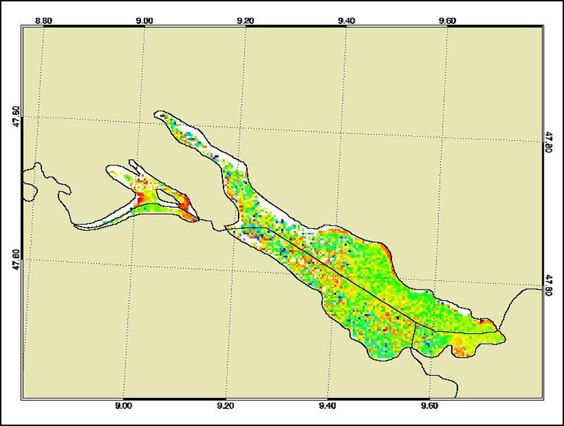
The Medium Resolution Imaging Spectrometer (MERIS) on Board ESA’s ENVISAT provides spectral high resolution image data in the visible-near infrared spectral region (412-900 nm) at a spatial resolution of 300 m. For more details on ENVISAT and MERIS see http://envisat.esa.int/ This product developed in the frame of the MAPP project (MERIS Application and Regional Products Projects) represents the chlorophyll concentration of Lake Constance derived from MERIS data. The product is a cooperative effort of DLR-DFD and the Institute for Coastal Research at the GKSS Research Centre Geesthacht. DFD pre-processed up to the value added level whenever MERIS data for the North Sea region was received and positively checked for a water area large enough for a suitable interpretation. For more details the reader is referred to http://wdc.dlr.de/sensors/meris/ and http://wdc.dlr.de/sensors/meris/documents/Mapp_ATBD_final_i3r0dez2001.pdf This product provides daily maps.
-
INSPIRE theme Sea Regions.